It was eagles and lemonade and sharp spiky plants all the way down.
I posted a meetup event to hike Eagle Mountain, a DPS peak in the southern part of Joshua Tree. Three people RSVPed, and all three silently flaked. So I decided to do it solo. Generally it's a very unwise idea to do an unfamiliar, rarely-visited, off-trail desert scramble alone, but needs must.
The hike's stats look easy: about 10 miles RT & 2400' of gain. The first three miles are largely flat and I thought that'd be the easy part. At least for me (if not others), it wasn't. I was trying to follow the AllTrails track (link), and that resulted in getting off track, then having to traverse to get back on track, rinse and repeat. At one time during the approach I was going up large boulders, then I had to go down them when I realized that wasn't the trail. Aside from a couple of rock steps, the approach is all in washes or on open dirt. If you're on boulders, you're off track. On many off-trail hikes you can at least occasionally see where you're going. This wasn't really like this. I think the thing to do is to just use the AllTrails track as a general guide and only seek it out if you aren't parallel to it or the going gets rocky.
Thankfully, once you get to the canyon the navigation gets easy and I put my phone away. However, because as usual I'd got a late start I decided it'd be best to turn around due to time. That was when I was about 600' below the summit and approaching a cirque. If the return had easier navigation I probably would have continued to the summit, but I didn't want to risk being out after dark given the navigation issues. The terrain in the canyon was a mix of dirt use trail, low Class 2, high Class 2, and maybe something that might be considered low Class 3. But, it's certainly no sheep.
The first image is looking down canyon from where I turned around, the second is looking up canyon, and the third shows some snow patches. It wasn't cold so they'll probably melt soon. I saw a natural hueco that might be helpful until it evaporates. While I saw some fresh scat from (probably) coyotes, the only animals I saw were lizards and a hare. The only other two-leggers I saw were at the Cottonwood campground.
Next time, I'll start earlier and not try to match the AllTrails route step for step. I'd left knee-high gaiters in my car and those would have been helpful (see the image). Likewise with a wrist strap for my phone. While my phone still had a charge and I had the map on a backup, bringing a power brick would have provided a bit of piece of mind.
My usual stop when traveling back on the 10 is the Long John Silver's in Yucaipa for fish and chips (or their equivalent). However, due to a freeway delay they'd already stopped serving fish by the time I got there. So, I need to go back for that too.
UPDATE: The NPS says:
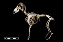
"Given your location in the Park (Eagle Mtns), I would assume that it is a section of the spinal column of a bighorn sheep. Check out the photo of the skeleton below. The piece you found is likely from the area near the shoulders."
I added the photo.


